This is the first post of my Summer 2006 Beijing tour - the first post since I was in Beijing last Fall. Because this trip is all about learning Chinese ,and lacks the frequent sightseeing and the continuous picture-moments of last year's AU abroad experience (not to mention because Google Earth is just so much fun and I've been playing around with it this afternoon), instead of kicking off the '06 version of this blog with a picture I'm posting a Google Earth image.
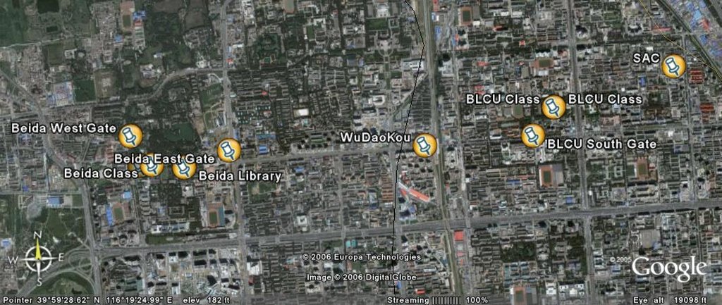
The image here basically encompasses all the important landmarks that make up my world right now. On the far-right is the Student Activities Center (SAC) which is where I am living. To the left of it is the building I have Chinese class in every weekday - it is located just inside BLCU's East gate. Also labelled is BLCU's West gate because it is the other primary entrance, and if you head West along the street outside West gate (Chengfu Lu) you will see WuDaoKou - this is the local subway station and surrounding shopping/eating area. Heading further down Chengfu Lu to the West you can see that the street deadends at Beida's campus - Beijing's, and China's, most famous university where I studied last year. On the West side of Beida's campus is my old dorm and the West gate.
Using Google Earth's measuring tools I determined the following:
SAC is 0.73 miles from my BLCU class as the bird flies; the distance by my normal cab/walking route in the morning is 1.33 miles.
My walking/bus route back to SAC is 1.3 miles from BLCU's South gate. This is my typical route home in the afternoons. Chaoshifa, my local grocery store, is along this route.
Also: it is an approximately 2 mile walk from SAC to WuDaoKou, and about a 3 mile walk to Beida. As the crow flies it is 3.17 miles from SAC to my old Beida dorm.

posted by Matt Powers at 7/23/2006 10:11:00 PM
![]()

0 Comments:
Post a Comment
<< Home